Map, Sign or Landmark: Three Ways to Find Your Way
Festival wayfinding works better when maps show the whole site, signs guide each turn and landmarks make places easier to remember and meet.
The common festival wayfinding mistake is asking one map to do every job. A visitor needs to find a stage, return to a friend or work out where they are; forcing all three tasks onto one tool costs time and attention. Festival wayfinding works better when maps, directional signs and landmarks each handle the task they suit.
What does each wayfinding tool do best?
A printed map shows how the site fits together. It helps visitors compare destinations, understand the shape of the grounds and choose a route before setting off. It is strongest when someone needs the whole picture, not an instruction at every junction.
Directional signs answer a narrower question: which way now? They work at decision points, such as a fork in a path or the approach to a cluster of stages. A sign is useful only if visitors can read it in time to choose the marked route.
A landmark is a recognisable feature that helps people locate themselves or agree on a meeting place. It might be a brightly painted water tower, a distinctive sculpture or a grove of tall trees. Landmarks are easy to refer to in conversation, though they do not necessarily tell a visitor how to reach the next destination.
Think of the three as a kitchen drawer: the map is the tray showing where things belong, a sign is the label on one compartment, and a landmark is the unusual spoon everyone recognises. None is much use for every task.
Which tool fits the visitor’s situation?
- Choose a printed map: Check whether visitors need to compare several destinations or understand how stages, food, toilets and exits relate. If they do, show paths and useful places with a simple legend and legible names; if they need only the next turn, add a directional sign instead.
- Choose directional signs: Check whether visitors must make a turn or approach a destination from more than one direction. If so, place a brief sign before each decision point; if the route is simple and visitors need the broader layout, use a map rather than adding redundant arrows.
- Choose landmarks: Check whether a feature is distinctive and visible from likely routes. If it is, give it one consistent name on signs and maps for orientation or meeting; if it is hidden, temporary or easily confused with another feature, use a different reference and direct signs.
For an unfamiliar site, a useful arrangement is often a map for orientation, signs for route decisions and landmarks for shared references. That is not a reason to duplicate every instruction three times. Give each tool a clear role, then check that their names and directions agree.
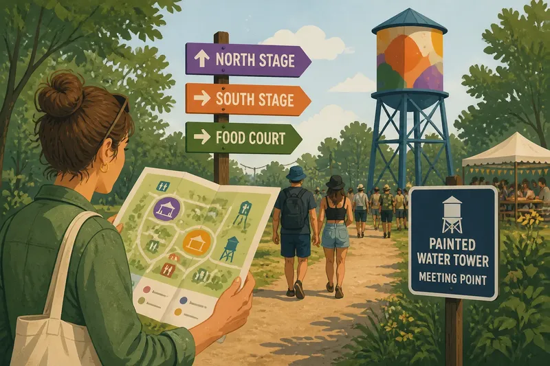
Say, in an invented situation, a festival has two stages beyond a wooded path and a painted water tower near the central food court. The organiser marks the stages and tower on the map, places arrows at the path junction and uses “Painted Water Tower” consistently as a meeting reference; a first-time visitor can check the layout, follow the turn and identify the meeting place. The observable result would be a route with fewer points where the visitor has to stop and guess, though no set of signs can prevent every wrong turn.
How should maps, signs and landmarks work together?
Start with the decisions visitors must make. A map should use the same place names as the signs, while signs should point towards destinations that appear on the map. If a route changes, update every affected reference rather than leaving one confident-looking arrow to tell an old story.
Place signs before a junction, not after it, and make their wording specific: “North Stage” is more helpful than “Music”. At a busy crossing, avoid arranging several arrows so closely that their destinations are hard to match. A sign should reduce uncertainty, not create a small reading exam.
Choose landmarks for distinctiveness and visibility from likely routes. A feature hidden behind a stage wall or repeated across the site is a poor reference. If a landmark is temporary or likely to be obscured, do not make it the sole way to identify an important service.
What questions help choose between a map, sign and landmark?
When is a festival map more useful than signs?
A map is more useful when visitors need to compare locations or choose among several destinations before walking. Signs take over at the point where a specific turn needs to be made.
Can landmarks guide visitors without a map?
Landmarks can help people describe where they are and arrange to meet, especially when the feature is visible from common routes. They are less dependable for describing a full route, so pair them with signs where people must choose a path.
What makes a festival sign easy to follow?
Use a clear destination name, a visible arrow and placement before the decision point. Keep the wording consistent with the map, and remove directions that compete for attention.
What if the grounds change during the festival?
Mark closures, diversions and relocated services on the map and signs, then remove or cover directions that no longer apply. If a landmark disappears from view, provide another clear reference rather than asking visitors to infer the change.
How can you check the wayfinding before opening?
Walk the main visitor routes from different starting points and note where a person would need to stop and decide. Check the approaches to stages, toilets, food areas and exits, including the return route from each destination. A route that seems obvious from an organiser’s desk may look quite different from a fork in a crowd.
Read signs from the direction people will approach, then compare their destination names with the map. Ask someone unfamiliar with the site to find a named place using the information available on the grounds; watch where they hesitate and revise that point rather than adding signs everywhere.
For festival wayfinding, use the map for the broad layout, signs for turns and landmarks for memorable shared references. Choose according to what the visitor must do next: compare, turn or recognise. Consistent names matter just as much as the tools, because a route is useful only if the destination stays recognisable along the way.